
CONCESSION APPLICATION
NAWEP - Norwegian Airborne Wind Energy Pilot
Airborne Wind Energy Plant at Lista Airport, Farsund Municipality
Applicant: Kitemill AS Date: 11 February 2026 Version: Revised following dialogue with NVE (ref. meeting 06.01.2026)
TABLE OF CONTENTS
- 1Executive Summary
- 2About the Applicant and Project
- 3Municipal Anchoring and Process
- 4Maps and Delineation
- 5Technical Description
- 6Grid Connection and Electrical Infrastructure
- 7Land Use and Facility Components
- 8Biodiversity
- 9Birds and Migratory Birds
- 10Landscape and Visual Impacts
- 11Acoustics
- 12Shadow Flicker
- 13Outdoor Recreation and Common Land Use
- 14Cultural Heritage and Cultural Environment
- 15Public Health and Residential Environment
- 16Co-use and Coordination
- 17Natural Hazards and Safety
- 18Cumulative Impact
- 19No-action Alternative
- 20Mitigation Measures
- 21Commitments
- 22Appendices
1. EXECUTIVE SUMMARY
1.1 Project Description
Kitemill AS applies for a concession to establish NAWEP (Norwegian Airborne Wind Energy Pilot) — an R&D project for airborne wind energy (AWE) at Lista Airport in Farsund Municipality.
Key Figures: - Installed capacity (grid injection): 1.2 MW (12 production units of 100 kW each + 3 R&D units) - Expected annual production: Approx. 4.2 GWh at mature operation (3,500 full-load hours) - Operating altitude: 150–500 metres above ground level - Planning area: Approx. 1.5 km² within the airport's existing industrial area - Project period: 2026–2031 (6 years: 2 years installation, 3 years operation, phased)
1.2 Comparison with Conventional Wind Power
Note: NVE's application template for wind power plants is designed for conventional turbines with permanent foundations and access roads. Airborne wind energy (AWE) technology has fundamentally different characteristics, and corresponding topics are addressed through descriptions of ground stations, service areas, grid connection, operational patterns and operational restrictions in the relevant chapters.
| Aspect | Conventional Wind Power | AWE (Airborne Wind Energy) |
|---|---|---|
| Height | Fixed tower height (typically 80–150 m) | Operating altitude 150–500 m |
| Foundation | Large concrete foundations | Light ground station on steel frame |
| Roads | Requires access roads | No new roads required |
| Visual impact | Permanent, static | Only visible during operation |
| Flexibility | Fixed location | Can be landed/removed quickly |
1.3 Phased Implementation
To safeguard the precautionary principle (Nature Diversity Act §9), the project is implemented gradually:
| Year | Activity | Systems |
|---|---|---|
| 2026 | Test flights R&D units, daytime only, monitoring programme established | 1–3 (R&D) |
| 2027 | Installation of stations M, N, O under observation | 3 |
| 2028 | Installation of stations A–L, grid connection, commissioning | 15 |
| 2029 | Operation Year 1 — full operation | 15 |
| 2030 | Operation Year 2 — continued operation and optimisation | 15 |
| 2031 | Operation Year 3 — conclusion and final evaluation | 15 |
1.4 Strategic Significance
Airborne wind energy (AWE) represents a new approach to wind power production where a wing profile operates at higher altitudes (200–500 m) with access to stronger and more consistent wind resources than conventional turbines. The technology is still immature and under active development internationally, but efforts are underway through initiatives such as IEA Wind Task 48 and the EU's Horizon Europe programme to bring it towards commercial maturity.
International context. AWE is recognised as an emerging technology within several European and international frameworks:
- IEA Wind TCP Task 48: 11 countries, including Norway, collaborate on research and development of AWE technology through the International Energy Agency (IEA).
- EU funding: The NAWEP project is supported by the EU Innovation Fund (EU ETS), Grant No. 101038892. In addition, Kitemill participates in several other EU-funded projects that strengthen the company's technology development: AWE-KM2 (Horizon Europe, Grant No. 101189207), AWETRAIN doctoral network (Marie Skłodowska-Curie Actions, Grant No. 101168734) and 3D-Circular (European Health and Digital Executive Agency, Grant No. 101226256).
- Regulatory developments: Germany introduced in 2024 the world's first feed-in tariff for AWE systems through its Renewable Energy Sources Act (EEG), marking a transition from pure research to early commercialisation.
National context. The Energy Commission's report "More of everything — faster" (NOU 2023:3) identifies the need for at least 40 TWh of new power production by 2030. DNV's analyses (2024, 2025) indicate that Norway may become a net importer of electricity in the early 2030s, with demand growth exceeding new development. The development of conventional onshore wind power has simultaneously encountered significant challenges related to land use, environmental impact and local opposition. AWE technology has the potential to contribute to power production with significantly lower land use and material consumption than conventional alternatives, but this requires further technology development and documentation through projects such as NAWEP.
Technology potential at maturity. Although the technology is at an early stage today, the fundamental physical and system characteristics indicate that mature AWE technology can provide significant advantages compared to conventional wind power:
- Access to stronger and more stable wind resources at higher altitudes
- Significantly lower material consumption per unit of energy produced
- Minimal ground footprint compared to conventional turbines
- No permanent terrain interventions — relocatable installations
- Lower visual exposure
These characteristics are based on the system's physical operating principles and the company's calculations, and will be verified through the NAWEP project.
2. ABOUT THE APPLICANT AND PROJECT
2.1 Applicant
Kitemill AS Org. no.: 994 720 023 Address: Flyplassveien 40, 4560 Vanse Contact person: Thomas Hårklau, CEO E-mail: th@kitemill.com
2.2 Background
Kitemill AS is a Norwegian technology company founded in 2008, with its R&D headquarters at Lista Airport. The company develops airborne wind energy (AWE) technology that utilises stronger and more consistent winds at higher altitudes.
2.3 Project Objectives
NAWEP is primarily a research and development (R&D) project with the following main objectives:
- Demonstrate AWE technology under Norwegian climatic and regulatory conditions
- Document and assess environmental impacts, with particular emphasis on birds and migratory birds
- Develop operational protocols for coexistence between AWE operations and natural values
- Establish a knowledge base for future commercial rollout of the technology
- Contribute to increased knowledge about birds and migratory birds at Lista, including spring migration and AWE-specific bird behaviour
Knowledge building: The applicant has a stated objective of contributing to knowledge building both before and throughout the entire project period. This involves systematic collection and sharing of data on bird activity, the technology's impact and the effectiveness of mitigation measures. All collected knowledge will be shared with relevant authorities and contribute to the overall knowledge base for AWE technology in Norway.
The project is partially funded by the EU, reflecting the project's relevance within the EU's framework for the energy transition.
2.4 Societal Benefits
2.4.1 Regional Energy Situation
Southern Norway (price area NO2) has in recent years experienced the highest electricity prices in the country. In December 2024, the spot price in NO2 reached NOK 13.16/kWh (Nord Pool), among the highest recorded for the price area, and throughout 2025 prices in southern price areas have been a majority of times higher than in Northern Norway. The reason is limited transmission capacity between north and south, combined with export through international interconnectors.
Any new local power production in the region contributes directly to strengthening security of supply and reducing price pressure. The NAWEP project, with its 1.2 MW installed capacity and expected annual production of up to 4.2 GWh at mature operation, will provide a limited but real contribution to regional power production. The project's primary value in this context is, however, the knowledge it generates about AWE technology's suitability for large-scale deployment in the region.
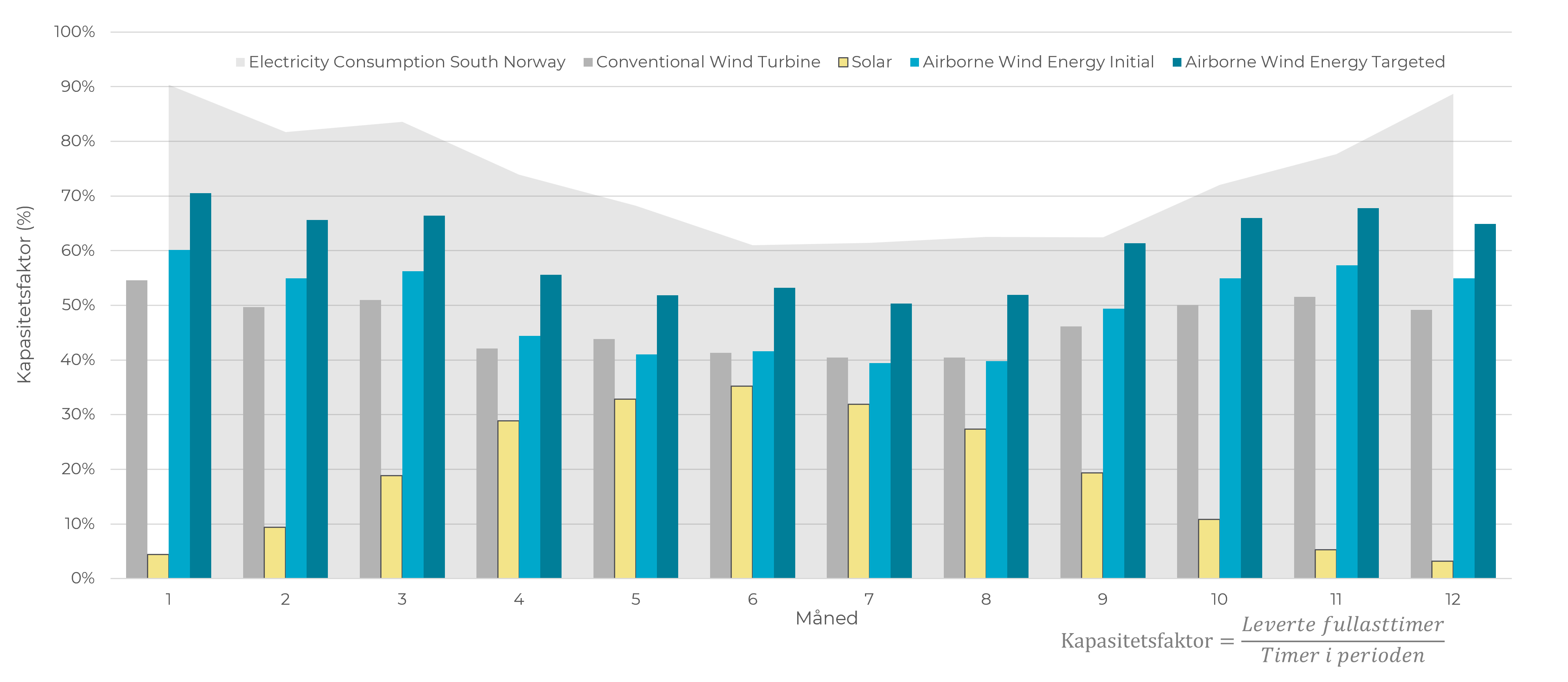
AWE technology's production profile has characteristics that are relevant for security of supply. The figure below shows monthly capacity factor for AWE compared to conventional wind power and solar energy, set against electricity consumption in Southern Norway. AWE achieves a higher capacity factor than conventional wind power throughout the year, and the production profile follows the consumption curve more closely than both solar and conventional wind. Solar energy has the highest capacity factor in summer when consumption is lowest, while AWE has the highest production in the winter months when consumption and prices are highest. This complementarity makes AWE technology relevant for security of supply in Southern Norway.
2.4.2 Local Value Creation
The project entails direct local activity through:
- Kitemill AS has its R&D headquarters and workshop at Lista Airport with permanent staff
- Installation, operation and maintenance of 15 ground stations over the project period
- Construction of grid connection and internal infrastructure in collaboration with local suppliers
- Collaboration with Farsund Municipality, landowners and local stakeholders
2.4.3 Knowledge Building and Industrial Development
Kitemill is among a limited number of active AWE developers globally that combines long-term field testing, regulatory interaction and participation in international research and coordination frameworks. The company participates in several EU-funded research and innovation projects and is an active participant in international AWE coordination through IEA Wind TCP Task 48. In contrast to many AWE initiatives that are primarily laboratory- or model-based, Kitemill's work is characterised by long-term outdoor operation, concession processes and interaction with grid, aviation and environmental authorities. This gives Kitemill a relevant role as a reference for applied and deployment-oriented AWE development, supplementing more academically oriented initiatives within the field.
The project contributes to knowledge building at several levels:
- Technical: Documentation of system performance, availability and production under Norwegian conditions
- Environmental: Systematic collection of data on coexistence with birds and natural values
- Regulatory: Experience base for development of Norwegian regulations for AWE technology
- Industrial: Development of value chain, supplier networks and competence centres
2.4.4 European and Global Context
The EU Innovation Fund has awarded the project EUR 3.35 million, reflecting an assessment of the project's relevance for the European energy transition. The EU's climate framework (Fit for 55, RED III) sets a target of at least 42.5% renewable energy by 2030, and the EU needs an estimated 510 GW of wind power capacity to achieve this target. AWE technology may in the longer term supplement conventional wind power, particularly in areas where traditional development faces area constraints.
Norway's climate commitments (55% reduction by 2030, 70–75% by 2035) require a significant increase in renewable power production. NAWEP contributes to developing a technological alternative that at maturity can make a substantial contribution to this transition.
3. MUNICIPAL ANCHORING AND PROCESS
3.1 Contact Person in Farsund Municipality
See appendix: Contact persons and stakeholders
The municipality's case officer for Kitemill's original dispensation application in 2018 has knowledge of the project from an early phase.
3.2 Dialogue and Inception Meetings
Kitemill has maintained ongoing dialogue with Farsund Municipality since 2017. Key milestones are summarised below:
| Date | Meeting/Event | Participants | Decision/Conclusion |
|---|---|---|---|
| 12.12.2017 | Application for temporary test facility | Kitemill AS | Submitted to municipality |
| 22.03.2018 | Technical Committee, case 18/41 | Thomas Hårklau presented | Unanimously approved with conditions for bird monitoring |
| Feb 2025 | Dialogue meeting invitation v1 | Kitemill, Farsund Municipality | NAWEP project presented |
| 14.03.2025 | Dialogue meeting Lista Airport | Kitemill, Farsund Lufthavn AS | Lease agreement discussed |
| 28.03.2025 | Application for temporary dispensation for demonstration facility | Kitemill AS | Submitted to municipality |
| 17.06.2025 | Technical Committee, case 61/25 | Jan Hornung presented | Unanimously adopted with conditions |
3.3 Zoning Plan and Municipal Decisions
Lista Airport is regulated through the Municipal Sub-plan for Lista Airport and Business Park.
Zoning purposes: - Airport (primary purpose) - Industrial and commercial purposes - Agriculture, Nature and Outdoor Recreation areas (adjacent)
Decisions for Kitemill:
Current decision — Technical Committee 17.06.2025 (case 61/25):
"Pursuant to the Planning and Building Act §7, dispensation is granted from the airport zoning purpose in the municipal sub-plan for Lista Airport and Business Park with a view to establishing a demonstration facility for wind energy technology. The application is approved subject to the following conditions:
- The test period shall contribute to increasing the knowledge base regarding the technology's impact and consequences for birds. Prior to commencement of testing, a plan for how the knowledge level can be increased shall be submitted for approval by the municipality. The plan shall be presented to the County Governor of Agder for input before approval.
- During testing, an adequate safety level shall be maintained with regard to personal safety. Other public authorities are assumed to confirm that an adequate safety level exists."
- Archive case no: 25/00659-5
- Decision form: Unanimously adopted following the municipal director's recommendation
Justification from the municipality:
- The advantages of granting dispensation are assessed as clearly greater than the disadvantages, cf. Planning and Building Act §19-2
- The measure is of a temporary nature and consists of reversible and relocatable installations
- Contributes to new technology that may enable energy production with less environmental impact than current wind technology
- Bird monitoring is assumed as part of the approval
In the municipal proceedings, statements were obtained from the Civil Aviation Authority, the County Governor of Agder, neighbours and Farsund Lufthavn AS. All statements, neighbour comments and the applicant's responses are publicly available in the municipality's case documents (archive case 25/00659-5).
Previous decision — Technical Committee decision 22.03.2018 (case 18/41):
Kitemill has held a dispensation for test flights at Lista Airport since 2018. The original decision concerned a temporary kite test facility and was adopted unanimously with conditions for bird monitoring (archive case no. 2017/2456). The 2025 decision replaces and extends this dispensation to include the demonstration facility.
3.4 Schedule
Project Phases
| Year | Phase | Activity | Systems |
|---|---|---|---|
| 2026 | Preparation | Concession process, test flights R&D units, monitoring programme established | 1–3 R&D |
| 2027 | Installation phase 1 | Installation of stations M, N, O. Start of monitoring programme (field campaigns) | 3 |
| 2028 | Installation phase 2 | Installation of stations A–L, grid connection completed, commissioning | 12 (+3 = 15) |
| 2029 | Operation Year 1 | Full operation with 15 systems, operational shutdowns during peak migration periods | 15 |
| 2030 | Operation Year 2 | Continued operation, evaluation and optimisation | 15 |
| 2031 | Operation Year 3 | Final operational year, final evaluation and reporting | 15 |
GANTT Chart
Activity                          2026        2027        2028        2029        2030        2031
                                   Q1 Q2 Q3 Q4 Q1 Q2 Q3 Q4 Q1 Q2 Q3 Q4 Q1 Q2 Q3 Q4 Q1 Q2 Q3 Q4 Q1 Q2 Q3 Q4
─────────────────────────────────────────────────────────────────────────────────────────────────────────────
CONCESSION AND PERMITS
  Concession application NVE       ████████████████
  Aviation permit                  ████████████████████████
  Grid connection agreement                    ████████████████

PREPARATION
  Test flights R&D units           ░░░░░░░░████████████████
  Bird monitoring established          ████████████████────────────────────────────────────────────────────

INSTALLATION
  Stations M, N, O (3 units)                   ░░░░████████
  Stations A–L (12 units)                              ░░░░████████████████
  Grid connection and commissioning                        ████████████

OPERATION
  Year 1 - Full operation (15 systems)                                     ████████████████
  Year 2 - Operation and optimisation                                                      ████████████████
  Year 3 - Conclusion and evaluation                                                                     ████████████████

MONITORING AND REPORTING
  Bird field campaigns                --          --          --          --          --
  Annual reporting to NVE                                ▲           ▲           ▲           ▲
  Final evaluation                                                                            ████████
─────────────────────────────────────────────────────────────────────────────────────────────────────────────
Legend: ████ = Main activity  ░░░░ = Preparation  ──── = Ongoing  ▲ = Milestone  -- = Field campaign (see chapter 9.7)
Key Milestones (from EU Innovation Fund NAWEP)
| Milestone | Description | Planned |
|---|---|---|
| MS9 | All permits granted | Q2 2027 |
| MS12 | Financial close | Q2 2027 |
| MS15 | Construction work completed | Q4 2028 |
| MS16 | Grid connection completed | Q4 2028 |
| MS17 | Commissioning | Q4 2028 |
| MS18 | Operation Year 1 completed | Q4 2029 |
| MS19 | Operation Year 2 completed | Q4 2030 |
| MS20 | Operation Year 3 completed, project conclusion | Q4 2031 |
3.5 Local vs. Regional Handling
The project is processed by NVE as the concession authority under the Energy Act. Farsund Municipality has adopted a dispensation from the zoning purpose in the municipal sub-plan (cf. section 3.3).
County Governor's Appeal and Parallel Process
The County Governor of Agder advised against the dispensation in its consultation statement (9 May 2025) with reference to bird interests and the knowledge base, and appealed the decision after the municipality made its decision on 17 June 2025. The appeal is under consideration.
Farsund Municipality has upheld its decision following an overall assessment in which the administration weighted, among other things:
- That the measure is temporary and reversible
- That the primary purpose is to increase the knowledge base for new technology
- That studies of practical use in an area with abundant birdlife is a good way to increase the knowledge base
All case documents, including the County Governor's statement and appeal, the Civil Aviation Authority's positive statement (ref. 25/18542-2), neighbour comments and the applicant's responses, are publicly available in the municipality's archive (archive case 25/00659-5).
NVE has confirmed that the concession process can proceed in parallel with the appeal case at the County Governor's office. The applicant acknowledges the County Governor's concerns regarding birds, and refers to the project's phased approach and monitoring programme (cf. section 9) which are designed specifically to address the knowledge gap and document the technology's impact on birds under Norwegian conditions.
4. MAPS AND DELINEATION
4.1 Regional Overview Map
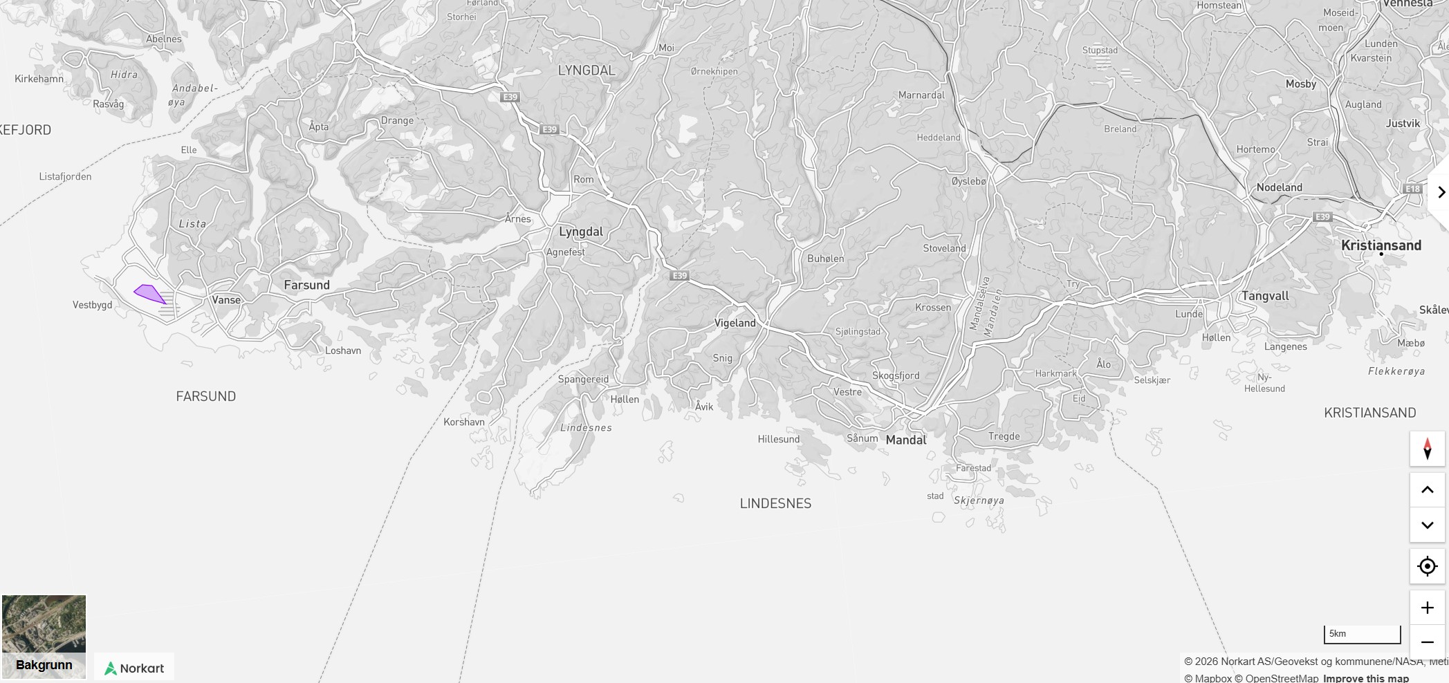 Figure 4.1: Regional overview showing the project area's location at Lista, Farsund Municipality. The project area is marked in purple.
Location: - Coordinates: 58.0995° N, 6.6264° E (airport centre) - Municipality: Farsund (municipality no. 4206), Agder County - Region: Lister Region, Southern Norway - Distance to nearest town: Farsund town centre approx. 8 km
Regional significance: Lista Airport is located on the Lista Peninsula, Norway's southernmost peninsula. The area has good wind resources and an extensive ornithological observation history that contributes to the knowledge base for assessment of airborne wind energy technology in the area.
4.2 Local Overview Map
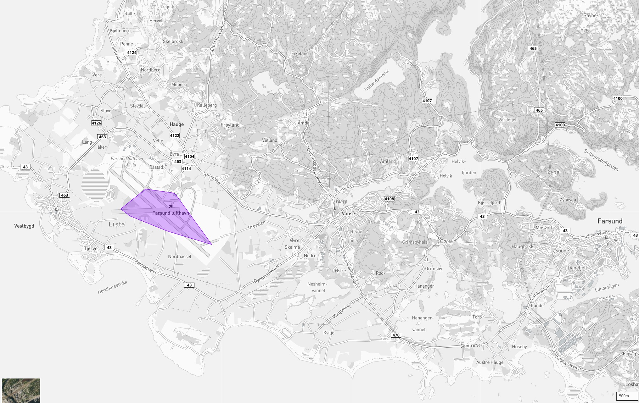 Figure 4.2: Local overview map showing the operations area (purple) at Farsund Airport in relation to surroundings. The map shows nearby settlements, road connections and topography.
Surroundings: - North: Agricultural land, West Lista cultural landscape, Nordberg - East: Lundevågen, Borhaug settlement - South: North Sea, Lista beaches - West: Slevdalsvatnet Nature Reserve
4.3 Planning Area Map with Station Placements
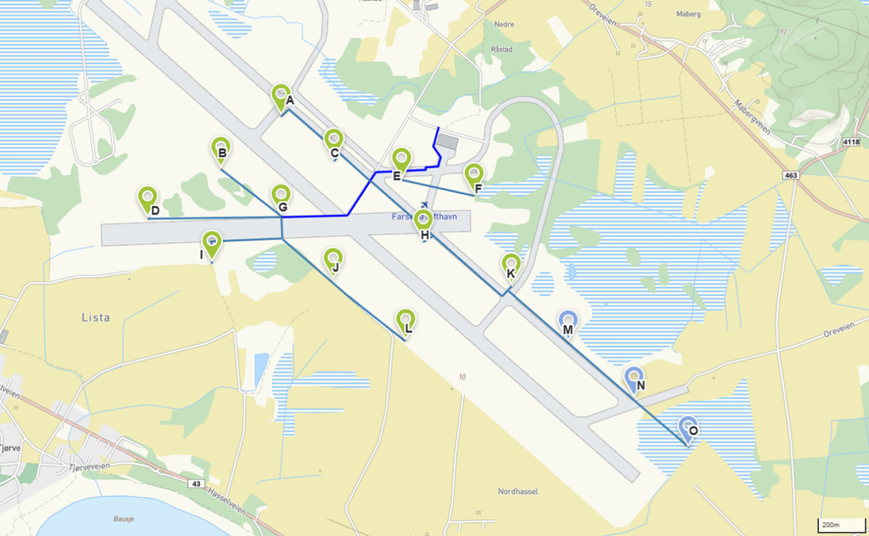 Figure 4.3: Planned station placements (A–O) with internal grid infrastructure (blue lines)
The planning area comprises: - Existing airport area within the fenced perimeter - Total approx. 1.5 km² (150 hectares) - 15 possible station placements marked A–O - Central connection point at point E (near terminal building)
KML files (can be opened in public map solutions):
- GRIDtegninger21.02.2025v1 m FoU punkt.kml — Grid layout with R&D points
- Operasjonsområdet tegninger6.11.2024.kml — Operations areas
- 250225_DangerArea.kml — Danger area (airspace)
4.4 Map with Settlement and Infrastructure
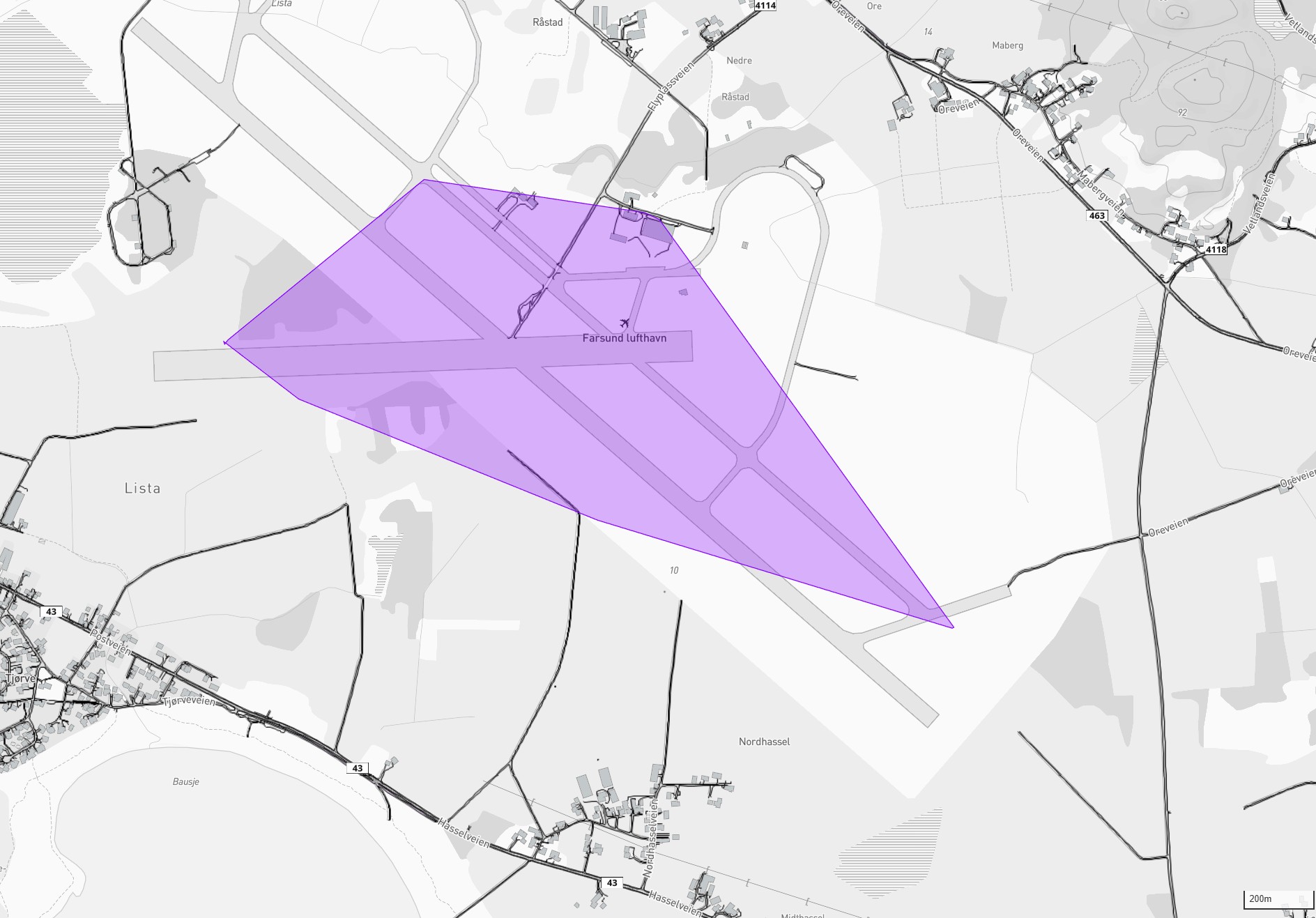 Figure 4.4: Detail map showing the operations area (purple) in relation to buildings, roads and other infrastructure. Lista settlement west of the airport, Nordhassel south.
Nearest settlement:
| Location | Direction | Distance from nearest station |
|---|---|---|
| Nordberg (individual dwellings) | North | approx. 500 m |
| Borhaug settlement | East | approx. 1,000 m |
| Vanse town centre | Northeast | approx. 3,000 m |
| Farsund town | East | approx. 8,000 m |
Road infrastructure: - County Road 43 (Listaveien) — south of the airport - Flyplassveien — internal access - No new roads required for the project
4.5 Map with Nature Considerations
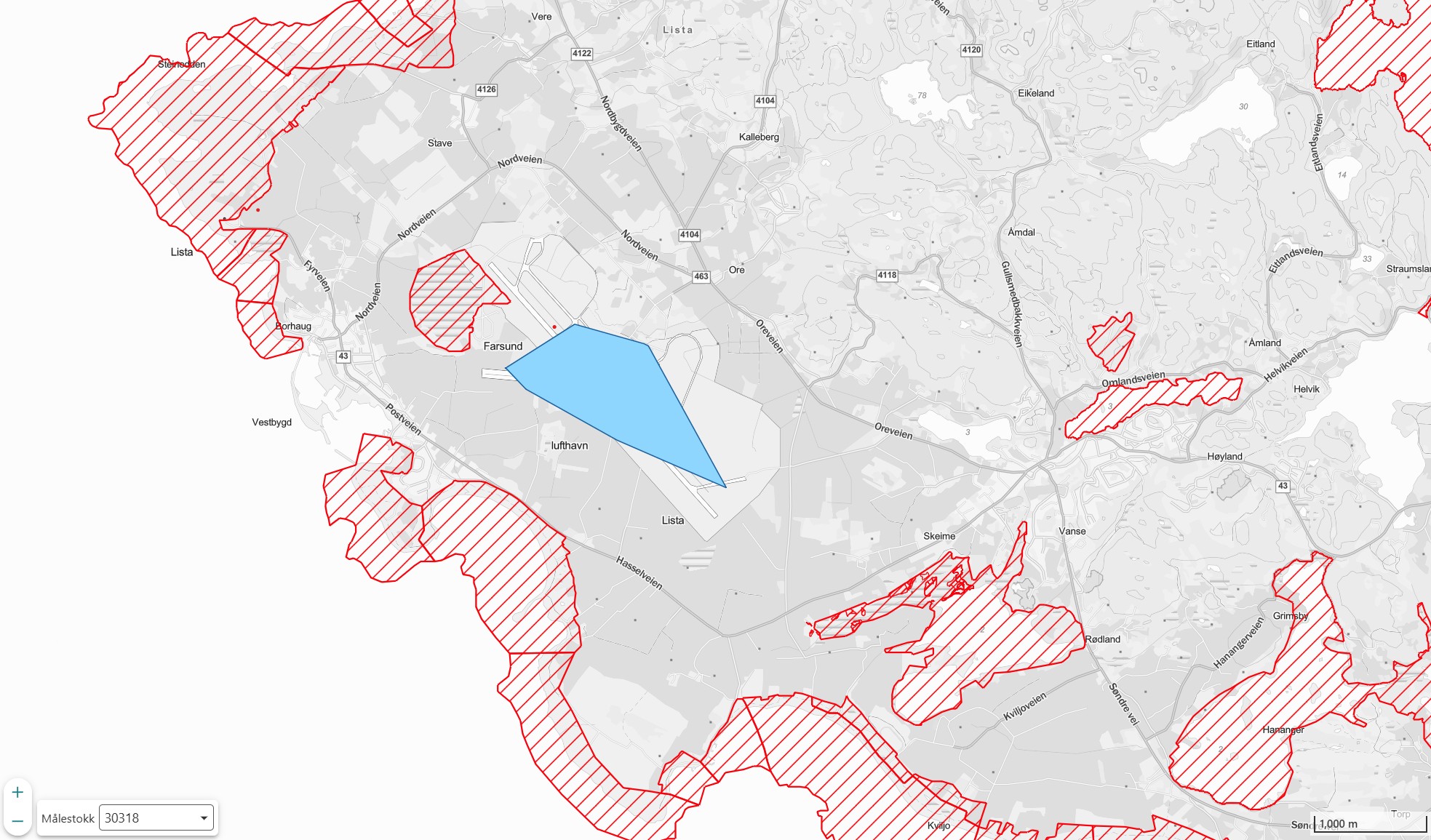 Figure 4.5: The operations area (blue) in relation to all protected areas in the region (red hatched areas). The map shows the project area's location relative to protected land. The project area does not overlap with protected land.
Protected areas nearby:
| Protected Area | Protection Type | Distance | Direction |
|---|---|---|---|
| Slevdalsvatnet Nature Reserve | Nature Reserve | approx. 330 m | West |
| Lista Wetland System | Ramsar | Adjacent | South/West |
| Listastrendene | Landscape Protection Area | approx. 500 m | South |
| Nesheimvatnet | Nature Reserve | approx. 1.4 km | Southeast |
Buffer zones: No station placements are located within the protected areas' boundaries. Minimum distance to Slevdalsvatnet Nature Reserve is approx. 330 m (from station D).
4.6 Operating Altitude
Note: For conventional wind power, tip height (highest point of rotor blade) is normally stated. For AWE systems, the operating altitude (the height at which the kite flies during production) is the relevant measure.
| Parameter | Value |
|---|---|
| Minimum operating altitude | 150 m above ground level |
| Maximum operating altitude | 500 m above ground level |
| Typical operating altitude | 200–400 m |
| Ground station height | Approx. 3 m |
4.7 Roads and Infrastructure
Note: AWE technology does not require access roads, unlike conventional wind power plants.
The project utilises existing infrastructure at the airport: - Existing paved runways and taxiways - Existing roads to the airport area - No new roads are planned
5. TECHNICAL DESCRIPTION
5.1 AWE Technology
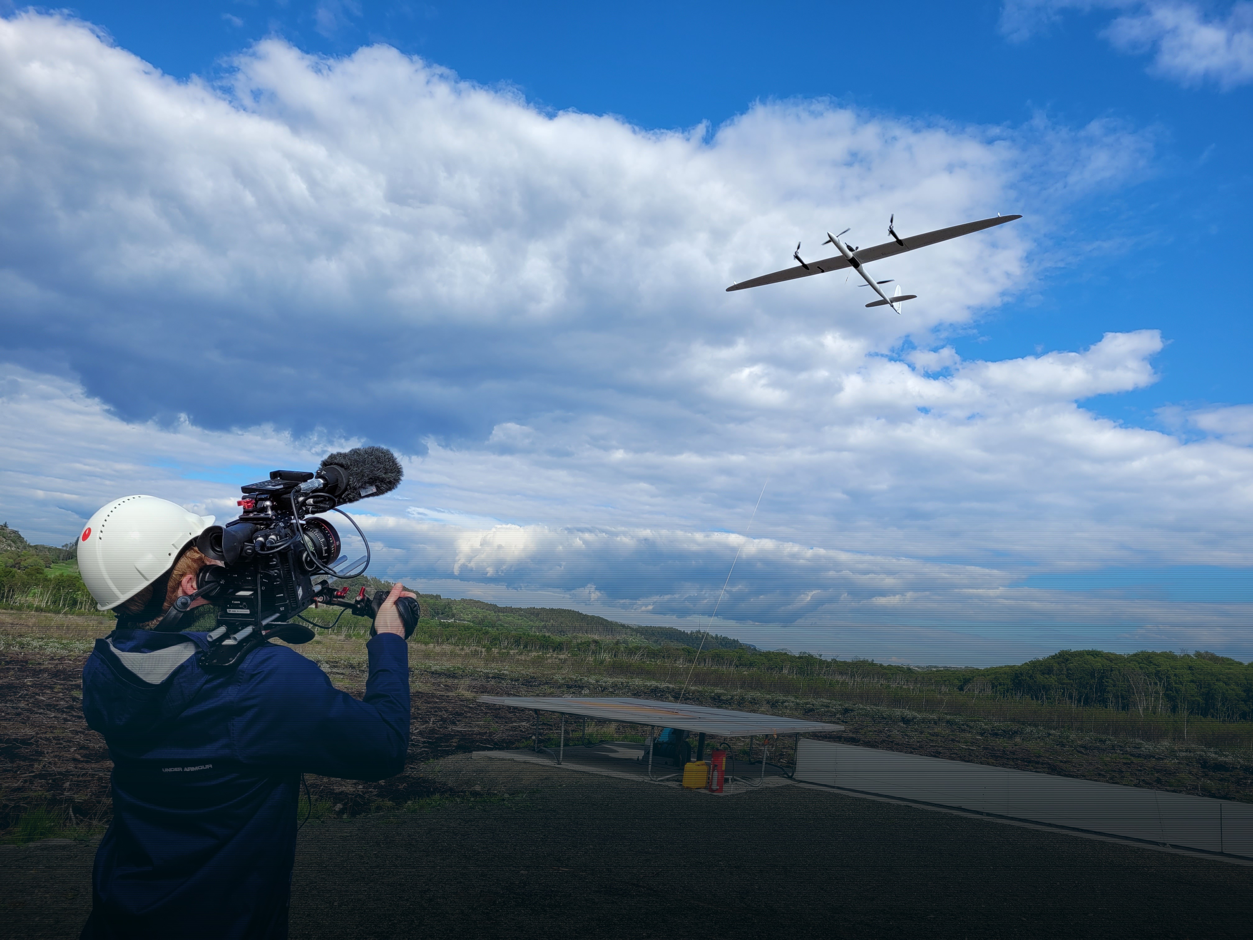
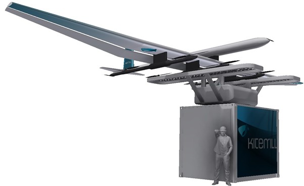
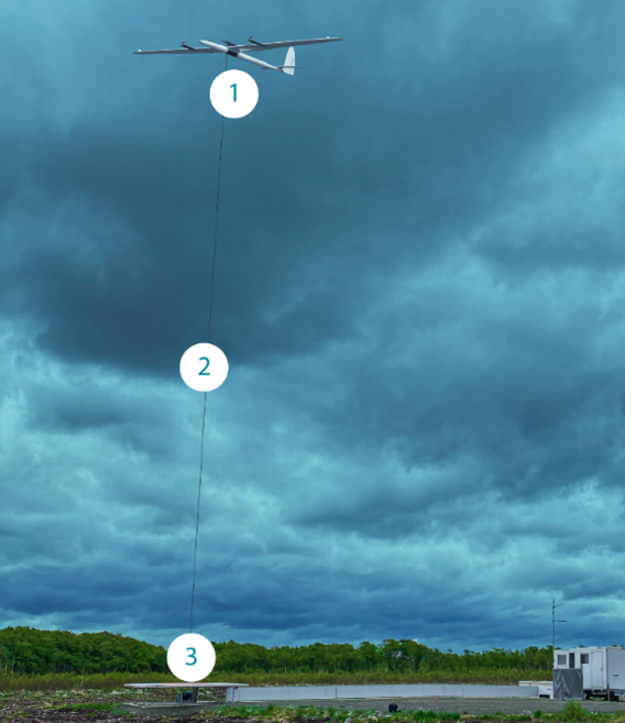 Figure 5.1: Kitemill's AWE system during operation at Lista Airport. (1) Kite — rigid wing with VTOL propellers, (2) Tether — high-strength synthetic line, (3) Ground station with generator, winch and control systems.
Kitemill's system consists of: 1. Kite (wing): Rigid wing with approx. 17 m wingspan 2. Tether: High-strength synthetic line (up to 1,500 m) 3. Ground station: Generator, winch and control systems
5.2 Production Cycle
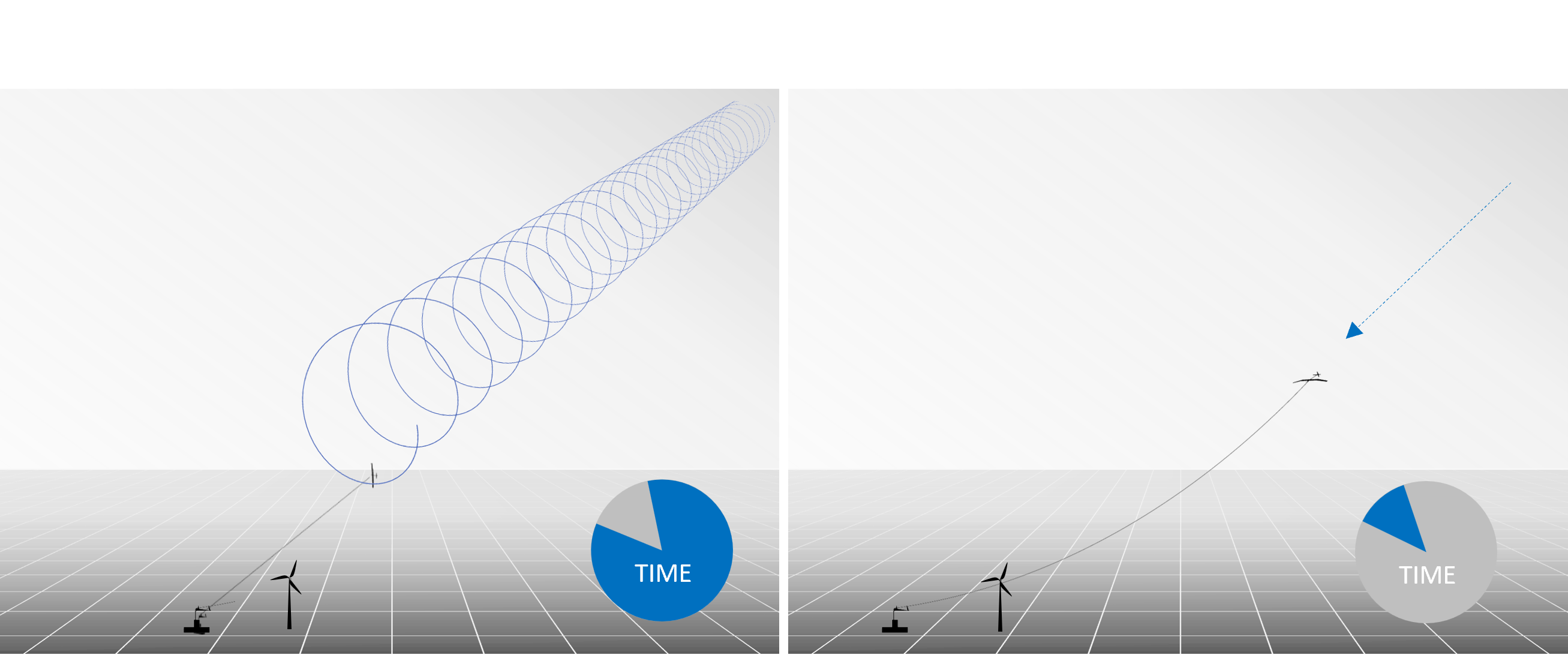 Figure 5.2: The production cycle. Left: Production phase — the kite flies in circular motion and reels out the tether while the generator produces electricity (constitutes the main part of the cycle time). Right: Return phase — the tether is reeled in with low energy consumption while the kite returns to starting position.
- Launch: The kite is lifted to operating altitude using VTOL propellers (like a drone)
- Production (reel-out): The kite flies in circular motion and reels out the tether with great force. The tether force drives the generator at the ground station. This phase constitutes the main part of the cycle time.
- Return (reel-in): The kite is steered to a low-drag position, and the tether is reeled in with low energy consumption.
- Repetition: The cycle repeats continuously. Net energy production is the difference between the production phase and the return phase.
- Landing: Automatic, during extreme weather or periodic maintenance.
5.3 System Specifications
| Parameter | Verdi |
|---|---|
| Power per system | 100 kW |
| Number of systems | 15 (12 operational + 3 R&D units) |
| Total installed capacity (grid injection) | 1.2 MW |
| Operating wind | 5–25 m/s |
| Kite speed | Up to 180 km/h (approx. 50 m/s) |
6. GRID CONNECTION AND ELECTRICAL INFRASTRUCTURE
6.1 Grid Connection Principle
The project connects to the regional grid via a new grid station at Lista Airport. Glitre Nett AS has in a maturity assessment dated 21.11.2024 (ref. IN-00002114) confirmed that the connection is assessed as MATURE and operationally sound.
The connection is made via: - New grid station replacing existing grid station 74013-LISTA FLYSTASJON - Two high-voltage metering points (Kitemill and Solkraft Lista) - Production cable from the ground stations to the grid station
6.2 Connection Point
Grid company: Glitre Nett AS See appendix: Contact persons and stakeholders
Connection point: - Transformer station: Vanse TS (110 kV / 22 kV) - Existing grid station: 74013-LISTA FLYSTASJON (to be replaced) - Capacity confirmed on distribution grid, regional distribution grid and transmission grid
6.3 Transformer and Electrical Infrastructure
| Component | Description |
|---|---|
| New grid station | Replaces 74013-LISTA FLYSTASJON |
| Metering points | 2 high-voltage (Kitemill + Solkraft Lista) |
| Distribution voltage level | 22 kV |
| Transmission voltage level | 110 kV |
| Cable routing | Underground cable, existing routes |
| Estimated cost grid station | 649,667 NOK |
6.4 Internal Grid
Grid specifications: - Total cable length: 5,180 m - Max power per unit: 180 kW - Continuous total delivery: 1,200 kW - Units: A–M with individual distances
[See appendix: Grid plan v1 and GridMap]
6.5 Installed Capacity and Annual Production
| Parameter | Verdi |
|---|---|
| Installed capacity (grid injection) | 1.2 MW |
| Production units | 12 units (station A–L) |
| R&D units | 3 units (station M, N, O) — not included in production calculation |
| Power per unit | 100 kW average |
| Expected annual production (mature operation) | 4.2 GWh |
| Full-load hours (mature operation) | 3,500 hours |
Production ramp-up plan:
| Year | Full-load hours | Annual production |
|---|---|---|
| 2027 | 800 hours | 960 MWh |
| 2028 | 1,200 hours | 1.440 MWh |
| 2029 | 2,000 hours | 2.400 MWh |
| 2030+ | 3,500 hours | 4.200 MWh |
Calculations based on PowerSim (version 37), validated against KM1 prototype testing.
Figure 6.1: Expected production ramp-up (MWh/yr). Actual production will be adapted to technology maturity and operational experience.
[See appendix: Maturity assessment Glitre Nett 21.11.2024]
6.6 Climate Benefit and Resource Efficiency
6.6.1 Greenhouse Gas Savings
Production of renewable energy displaces fossil-based power production in the European electricity market. The EU Innovation Fund's GHG calculation methodology uses an emission factor of 0.15 tonnes CO2 equivalents per MWh for the reference grid. Based on this, the project's climate contribution can be estimated:
| Parameter | Verdi |
|---|---|
| Emission factor reference grid (EU) | 0.15 tonnes CO2e/MWh |
| Annual production at mature operation | 4,200 MWh |
| Estimated annual CO2 savings at mature operation | ~630 tonnes CO2e |
Production will be ramped up gradually in line with technology maturation (cf. section 6.5). In an early phase, actual production and hence climate effect will be lower than at mature operation. The ramp-up plan reflects that this is a new technology where operational experience and adaptation to local conditions will affect the production level.
For comparison, 4,200 MWh corresponds to the electricity consumption of approximately 260 Norwegian households (based on average consumption of 16,000 kWh/year, SSB).
6.6.2 Resource Efficiency
AWE technology differs significantly from conventional wind power in material consumption and land use. Kitemill estimates, based on the company's system design, indicate the following comparisons:
| Parameter | Conventional wind power | AWE (Kitemill) |
|---|---|---|
| Material consumption | ~500 tonnes per MW | ~50 tonnes per MW |
| Ground footprint per unit | ~2,000 m² (foundation, road, assembly area) | ~36 m² (ground station 6×6 m) |
| Permanent terrain interventions | Concrete foundation, access roads, assembly areas | None — relocatable steel frame |
| Infrastructure | Special transport, crane operations, access roads | Standard vehicles, underground cables |
These figures are based on the company's own calculations and will be verified through the NAWEP project.
Figure 6.2: Comparison of material consumption and ground footprint (Kitemill estimates).
The fundamental material saving derives from the AWE system replacing tower, nacelle and rotor blades with a lightweight wing profile and a tether. The ground station with generator constitutes the main part of the material consumption.
The low material intensity also results in a shorter Energy Payback Time (EPBT). Faggian et al. (2019) estimate EPBT for AWE systems at approx. 5 months, compared with approx. 9.5 months for conventional wind power. The carbon footprint per produced kWh is correspondingly reduced.
6.6.3 Reversibility
A significant characteristic of AWE installations is that they can be removed without lasting traces in the terrain. The ground stations are bolted to the ground without concrete foundations, and internal cable infrastructure is laid as underground cable. Upon conclusion of the project, the area can be restored to its original condition without costly demolition work.
7. LAND USE AND FACILITY COMPONENTS
7.1 Ground Station
7.2 Service Area
- Existing hangars are used
- No new buildings are planned
7.3 Construction Phase
The construction period is estimated at approx. 12 months and comprises the following activities:
- Establishment of gravel pads at up to 15 locations
- Installation of internal cabling (underground cable)
- Deployment of ground stations and transformer stations
- Transport with standard vehicles (truck, crane truck)
Construction work involves no blasting, mass deposits or permanent terrain interventions. Noise and vibrations from construction machinery will be limited and of a temporary nature, equivalent to ordinary construction activity. After completion, affected areas will be restored to their original condition.
8. BIODIVERSITY
8.1 Area Description
The Lista area has recognised natural values and comprises: - Ramsar status (international wetland protection since 1996) - 1.3 million bird observations in the Species Data Bank - 34 red-listed bird species documented in the area
8.2 Protected Areas
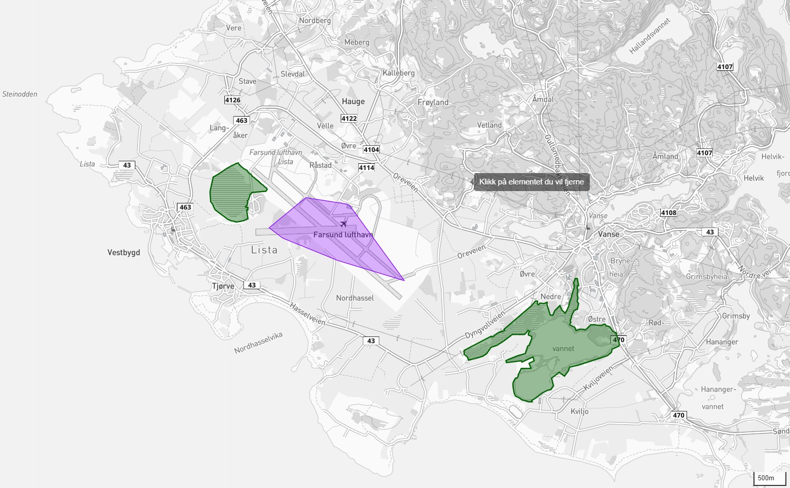 Figure 8.1: The operations area (purple) in relation to the nearest nature reserves: Slevdalsvatnet (west, green) and Nesheimvatnet (southeast, green). Both are part of the Lista Wetland System (Ramsar).
| Protected Area | Type | Distance |
|---|---|---|
| Slevdalsvatnet Nature Reserve | Nature Reserve | approx. 330 m west |
| Lista Wetland System | Ramsar | Adjacent |
| Listastrendene | Landscape Protection Area | approx. 500 m |
8.3 Habitat Types
The planning area comprises primarily airport areas and cultivated land. No threatened habitat types have been registered within the planning area.
In adjacent areas the following have been registered: - Oceanic bog (NiN), associated with the Atlantic raised bog habitat type - Coastal salt marshes - Coastal heathland
These are not affected by the project.
8.4 Red-listed Species
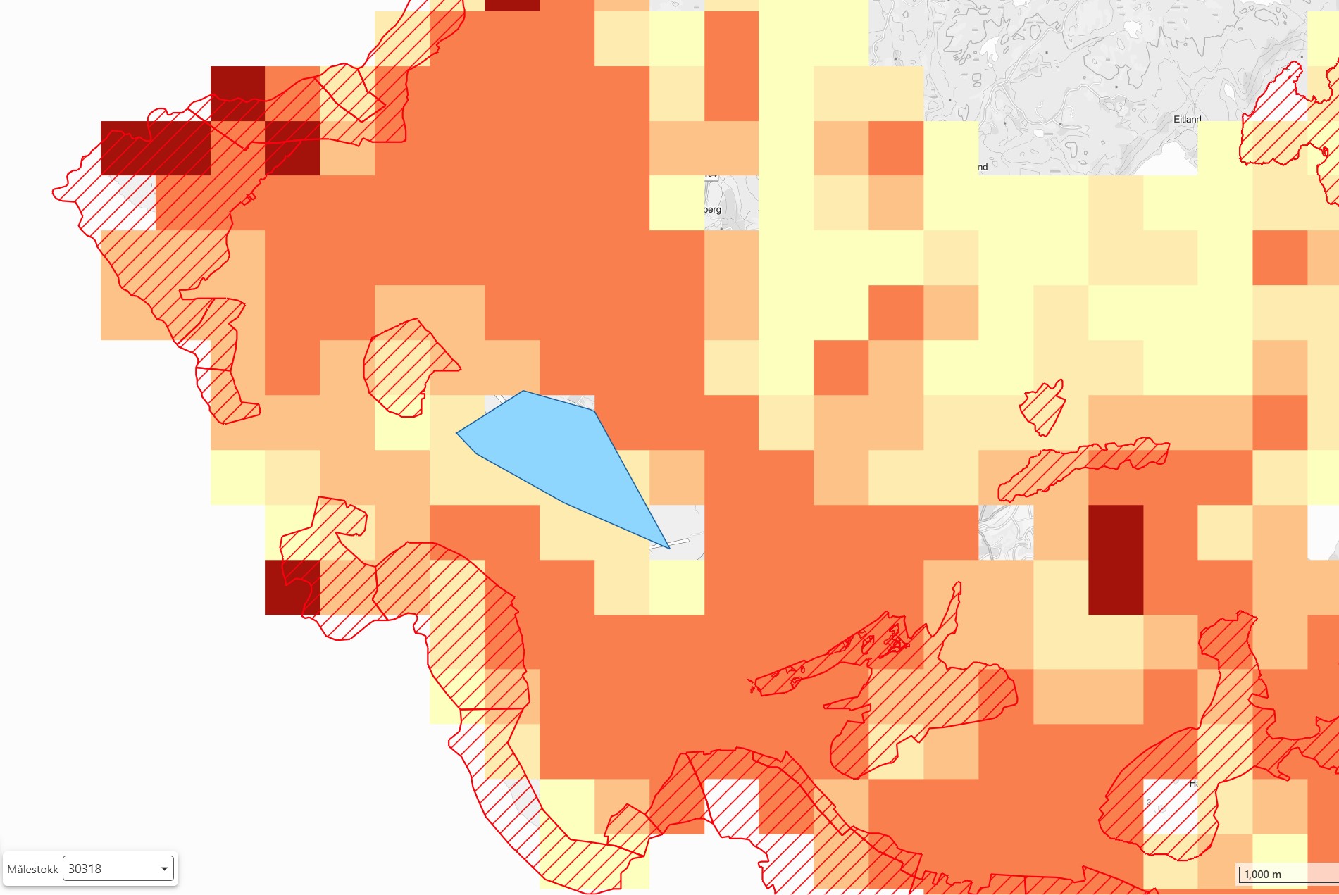 Figure 8.2: The operations area (blue) shown with protected areas (red hatched areas) and species registrations from the Species Data Bank (colour intensity indicates registration density). Most registrations in the area are related to birds. The project area is located in an area with moderate registration density compared to surrounding nature protection areas.
Based on the Species Data Bank, rare coastal plants have been registered in surrounding areas, including sea holly and soft hornwort. The species are associated with coastal stretches outside the planning area.
8.5 Assessment
The planning area is already heavily influenced by human activity. The AWE facility will have limited direct impact on habitat types as: - No new roads are built - Minimal ground interventions - Operation takes place in the airspace
9. BIRDS AND MIGRATORY BIRDS
This assessment has been prepared in collaboration with Arnold Haland, NNI Resources AS, based on NNI Report 520 (2018) and updated assessment (2024).
9.1 Summary
Lista is a recognised bird locality. The applicant has prepared a comprehensive plan for mitigation measures and monitoring in accordance with the Nature Diversity Act §§ 8-12.
9.2 Relevant Species
The following species have been specifically assessed in the monitoring programme: 1. Marsh harrier 2. Crane 3. Lesser black-backed gull 4. Common swift 5. Barn swallow 6. Skylark 7. Meadow pipit
9.3 Knowledge Base
Existing knowledge: - NNI Report 520 (2018), commissioned by Kitemill: 110 hours of fieldwork - Species Data Bank: 1.3 million observations - Updated assessment Arnold Haland (2024)
Knowledge building: Existing mapping of birdlife at Lista is extensive. The project will further strengthen the knowledge base in the following areas: - Spring migration: Mapping of spring migration will supplement existing data on autumn migration. - Altitude distribution: Systematic recording of bird flight altitudes in the planning area through the seasons. - AWE-specific response: Documentation of bird behaviour in the vicinity of AWE systems, which will contribute to the knowledge base for this new technology.
This knowledge building forms a central part of the project's monitoring programme, cf. Nature Diversity Act § 8.
9.4 Assessment of Scaling from 1 to 12 Systems
Arnold Haland (NNI) has in an updated assessment (November 2024) assessed the consequences of scaling from one test unit to 12 simultaneous systems. Key findings:
- Collision risk increases proportionally with the number of systems in operation, estimated at a minimum of 12 times the level observed in the 2018 study.
- Both visual and acoustic impact on birds increases, and birds must undertake more complex avoidance behaviour.
- There is a natural mitigating factor: strong wind correlates with lower bird activity in the airspace, which reduces the overlap between operation and bird exposure.
- Skylark has been identified as a vulnerable species, with breeding pairs on hangars in the area.
- Movement patterns along the airport's south side (west-east corridor) and the airspace towards Slevdalsvatnet require particular attention.
- The October migration represents a period of high bird activity. Spring migration has not yet been studied. These knowledge gaps are part of the justification for the R&D project.
9.5 Phased Ramp-up and Risk Management
To safeguard the precautionary principle (Nature Diversity Act § 9), the project is structured with a gradual ramp-up where operations are adapted based on accumulated knowledge:
| Year | Activity | Bird-related measures |
|---|---|---|
| 2026 | 1 system, daytime flying only | Negligible impact. Monitoring programme established (field campaigns spring/summer/autumn) |
| 2027 | Up to 4 systems (station K, M, N, O) | Day and some night flying under observation. Focus on migration periods spring and autumn |
| 2028 | 12 systems | Operational shutdown during the most active migratory bird period |
| 2029 | Partial operation with observation | Evaluation of impact based on data from 2028. Adaptation of operational patterns |
| 2030 | Full operation | Provided that the impact is assessed as acceptable in 2029 |
Most bird migration occurs at night. The most effective mitigation measure is operational shutdown during periods of high migratory bird activity. In case of unacceptable consequences, the plan can be adjusted or reversed.
The approach has been developed in dialogue with NNI Resources AS and builds on the knowledge base from the 2018 study and Haland's updated assessment (2024). Kitemill commits to sharing all collected data with the County Governor and NVE throughout the entire project period.
9.6 Mitigation Measures
- Gradual ramp-up over 5 years
- Daytime flying only in 2026
- Operational shutdown during peak migration periods (from 2028)
- Bird monitoring through field campaigns (spring, summer, autumn)
9.7 Field Plan 2026 and Subsequent Years
| Period | Number of sessions | Focus |
|---|---|---|
| Spring (April–May) | 2 | Spring migration |
| Summer (June) | 1 | Breeding birds |
| Autumn (Sept–Oct) | 2 | Autumn migration |
10. LANDSCAPE AND VISUAL IMPACTS
10.1 Landscape Character
The Lista Peninsula is characterised by: - Flat, open coastal landscape - Agricultural landscape with stone walls - Historical airport profile - Exposed towards the North Sea
10.2 Visual Impact
| Aspect | Assessment |
|---|---|
| Visibility | Kites visible on clear days up to 3–5 km |
| Movement | Dynamic, circular motion |
| Light marking | Not required (below 150 m when landing) |
| Reversibility | Fully reversible, no permanent structures at height |
10.3 Visualisations
The following visualisations show the AWE system in operation at Lista Airport. The images have been generated with 3D modelling based on actual station placements and operating altitudes.
10.3.1 Overview Images — Station Placements
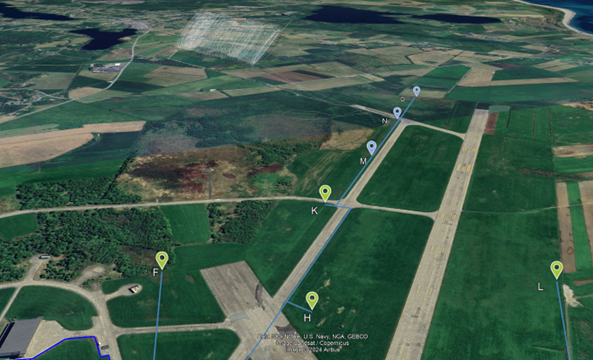 Figure 10.1: 3D view showing selected station placements (F, H, K, M, N, L) along the airstrip. Lines illustrate connections between stations and operations areas.
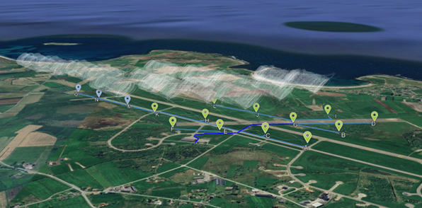 Figure 10.2: Overview of all 15 stations (A–O) with visualised circular motions for the kites in operation. Seen from southeast with the sea in the background.
10.3.2 Operational Pattern from the Air
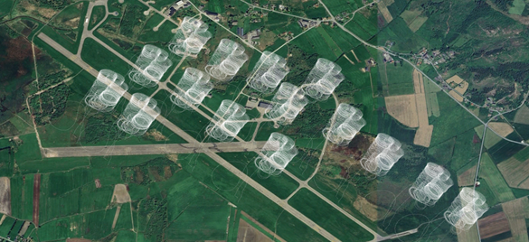 Figure 10.3: Aerial photo showing all 15 systems' operational circles seen from above. Each cylinder represents the area where one kite operates in circular motion.
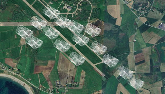 Figure 10.4: Alternative angle showing the operational pattern in relation to the airport's runways and surrounding landscape.
10.3.3 Visual Impact from Ground Level
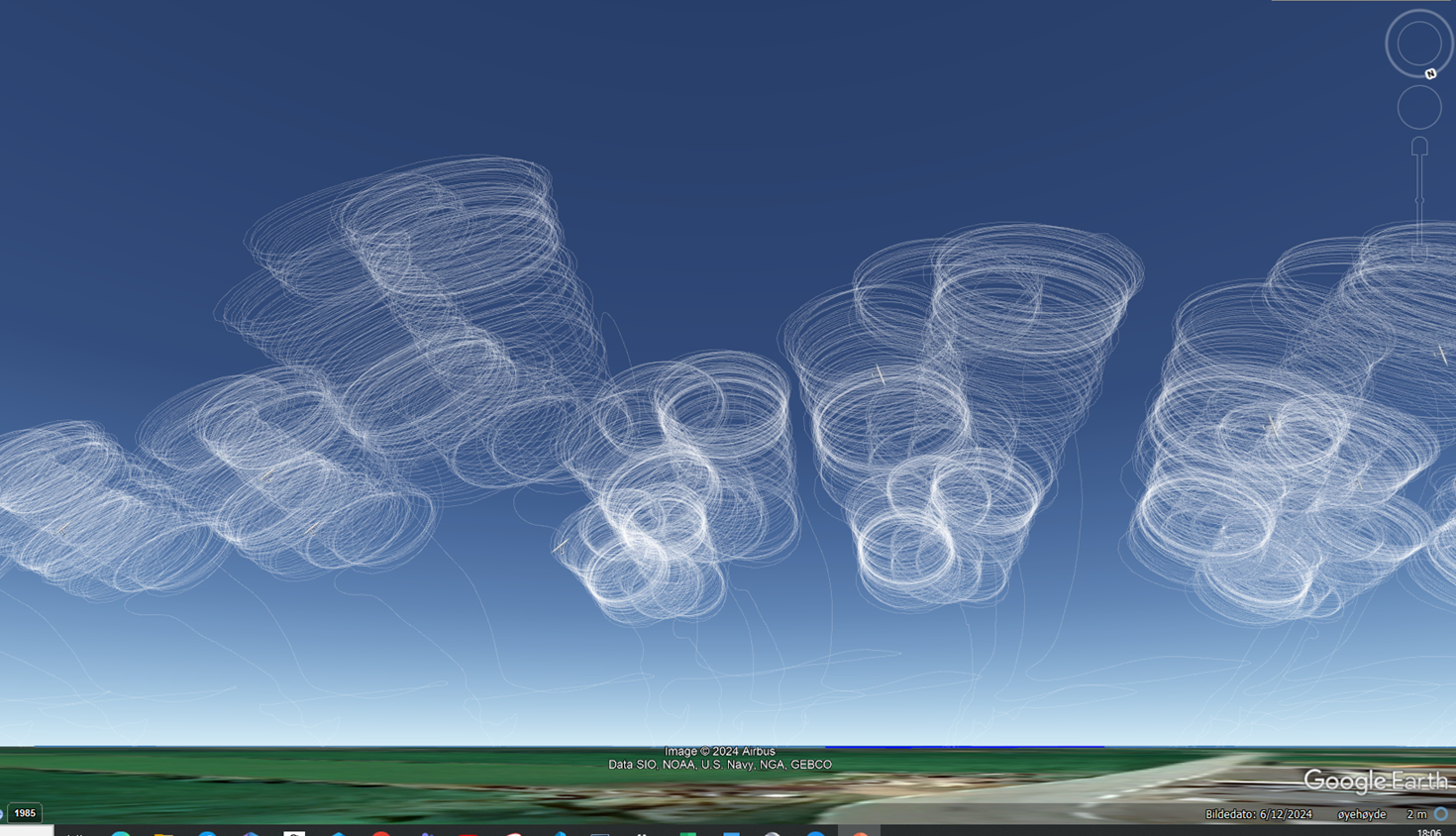 Figure 10.5: Visualisation seen from ground level showing the kites' circular motions against the sky. Operating altitude 200–400 m above ground.
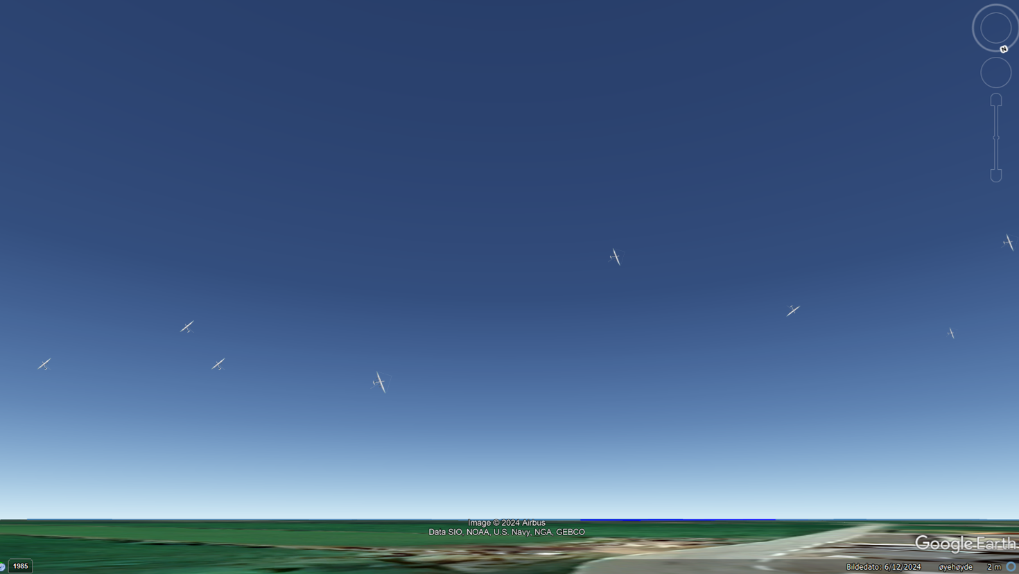 Figure 10.6: Visualisation from the airport area showing all 15 kites in operation. The kites (17 m wingspan) are visible as small objects against the sky at typical operating altitude.
10.3.4 Actual Photo from Flight
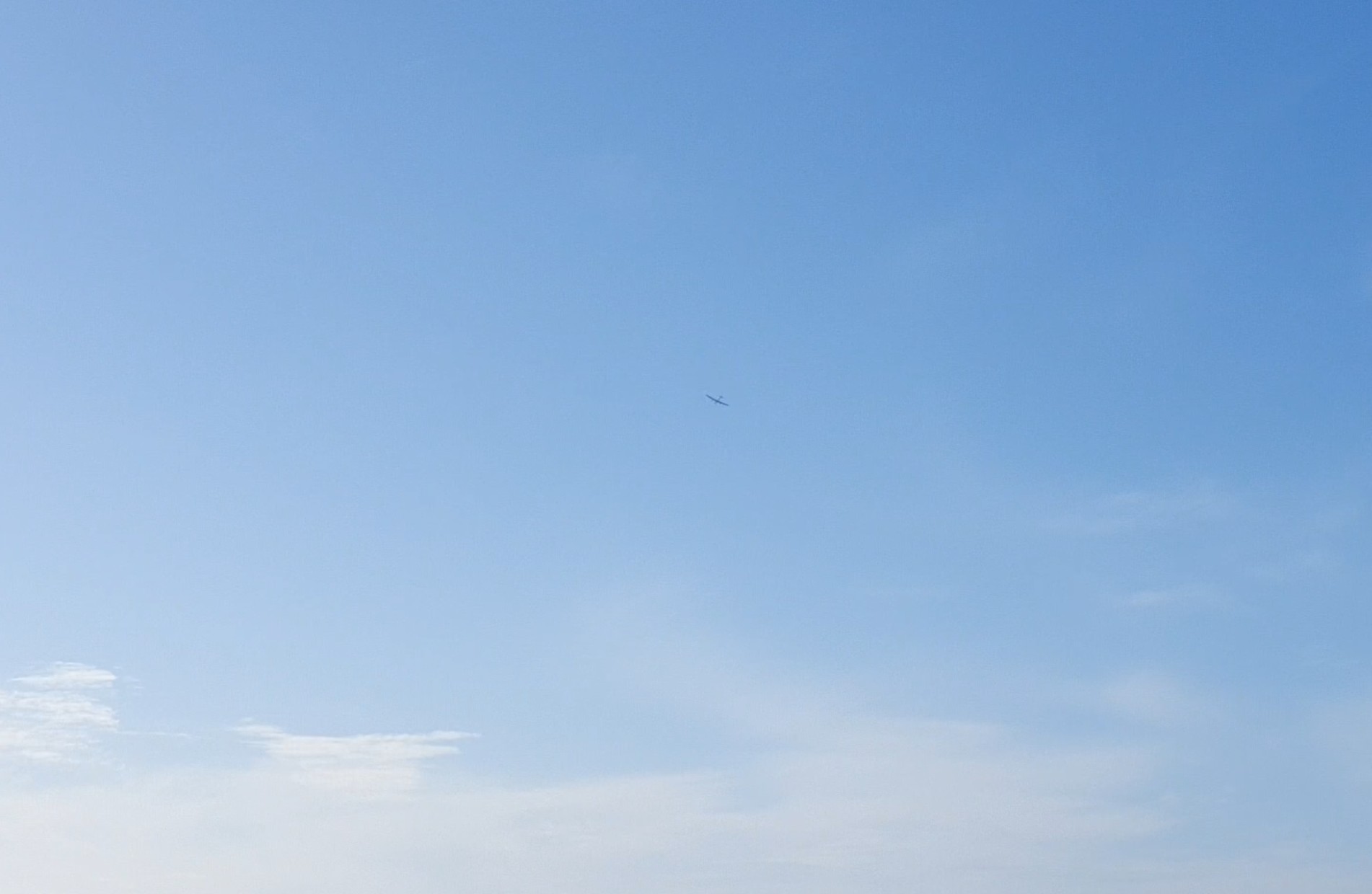 Figure 10.7: Photo from actual flight with Kitemill's KM1 system at Lista Airport. The kite does not cover the solar disc from normal operating altitude, and shadow flicker has not been observed.
10.3.5 Methodology
The visualisations have been prepared with the following methodology: - Background images: Satellite images and 3D terrain model from publicly available sources - Station placements: Based on actual coordinates from the planned grid layout - Operational circles: Visualised as cylindrical volumes with radius corresponding to tether length - Scale: The kites are presented at actual size (17 m wingspan) relative to the surroundings
Assessment of visual impact: - The kites are visible as small objects against the sky at distances over 500 m - No permanent structures above ground level other than ground stations (approx. 3 m height) - Dynamic movement (circles) differs from static wind turbines - Visual impact is assessed as moderate. The AWE systems' smaller physical dimensions and absence of permanent constructions at height give a different visual character than conventional wind power
11. ACOUSTICS
11.1 Knowledge Base
The knowledge base for the acoustic assessment is based on the following sources:
-
Inge Hommedal (2016): Early study for Kitemill conducted by a civil engineer with background from Kjelde akustikk AS and SWECO.
-
Bouman, N. (2023): Acoustic field measurements of Kitemill's KM1 system conducted at Lista Airport, March 2023. Master's thesis, Delft University of Technology. Available: https://repository.tudelft.nl/record/uuid:390a153c-0114-44c8-8b43-d9efc3e8cdd1
-
T-1442/2021: Norwegian guideline for treatment of noise in land use planning is applied for limit values.
The planning area is located within an existing noise zone from air traffic, mapped by Sweco (2020) as part of the airport's sequential requirements. The AWE facility's acoustic contribution comes in addition to this existing load.
11.2 Sound Sources During AWE Operation
The AWE system's sound sources are fundamentally different from conventional wind power:
| Sound source | Operational phase | Character |
|---|---|---|
| Tether vibrations | Production (main source) | Tonal, whistling sound |
| Aerodynamic wing noise | Production | Broadband |
| VTOL propellers | Launch/landing | Low-frequency (~100 Hz) |
| Generator/winch | Continuous | Low level |
11.3 Acoustic Measurements and Analysis
Field Measurements at Lista (Bouman, 2023)
Acoustic field measurements of Kitemill's KM1 system were conducted at the test facility at Lista Airport on 27 March 2023. The measurements were performed with a microphone placed on the ground, at a distance of 308–369 m from the kite during production flight.
Key findings: - Wind speed during measurement: 9.1 m/s (Lista Lighthouse) - Flight speed: 30–45 m/s - Flight altitude: 130–230 m - Dominant frequency peaks at 1,500 Hz and 2,000 Hz - Main sound sources identified as laminar boundary layer vortex shedding and tether vortex shedding
Summary
The field measurements at Lista confirm that the dominant sound source from AWE systems in production is vortex shedding in the tether and on the wing profile. The tonal character from tether vibrations is the most prominent sound component. Similar findings have been reported in international AWE research. Bouman's field measurements on Kitemill's own KM1 system provide system-specific data for frequency characteristics and sound levels.
11.4 Frequency Characteristics and Attenuation with Distance
The dominant frequency from AWE systems lies in the range 1,500–2,000 Hz. This is significantly higher than conventional wind turbines which typically generate low-frequency sound in the range 100–500 Hz.
This difference has great practical significance: high-frequency sound attenuates significantly faster with distance than low-frequency sound. The reason is air absorption — air molecules absorb energy from sound waves, and this effect increases with frequency. At 2,000 Hz, the additional attenuation from air absorption is significant already at a few hundred metres' distance. Low-frequency sound from conventional turbines (100–500 Hz) carries far, and it is precisely this that gives rise to neighbour complaints at traditional wind power plants.
The sound level also varies with flight speed through the production cycle. The launch and landing phase (VTOL propellers, ~100 Hz) constitutes less than 1% of total operating time.
11.5 Comparison with Conventional Wind Power
| Parameter | Conventional wind power | AWE (Airborne wind energy) |
|---|---|---|
| Main source | Blade passage, gearbox | Tether vibrations |
| Typical frequency | 100–500 Hz (low-frequency) | 1,500–2,000 Hz (high-frequency) |
| Amplitude modulation | "Swoosh" sound | Continuous tone |
| Attenuation with distance | Low (low-frequency carries far) | High (air absorption) |
Flight pattern and speed can additionally be adapted operationally to change the sound profile (cf. Bouman, 2023).
11.6 Norwegian Limit Values
The guideline for treatment of noise in land use planning (T-1442/2021) specifies the following limit values for wind power plants at residences:
| Zone | Limit value (Lden) | Description |
|---|---|---|
| Yellow zone | 45–50 dB | Noise-sensitive development may be erected with conditions |
| Red zone | >50 dB | Noise-sensitive development shall not be erected |
Distance to nearest residence:
| Residential area | Distance from nearest station |
|---|---|
| Nordberg | ca. 500 m |
| Borhaug | ca. 1 000 m |
Assessment: - The nearest residence (Nordberg) is located approx. 500 m from the nearest planned station - AWE technology's high-frequency sound profile means that the sound level decreases rapidly with distance - Sound levels at residences will be documented through measurements in the test phase - In case of any exceedances, operational restrictions or station placement will be adjusted
11.7 Mitigation Measures
- Operational management: Reduced flight speed as needed
- Geometry optimisation: Placement of stations for maximum distance to neighbours
- Time restrictions: Reduced operation in the evening/night as needed
- Monitoring: Continuous sound logging established in 2026
- Adaptation of operational pattern: Flight pattern and speed can be adjusted to optimise the sound profile (cf. Bouman, 2023). The applicant will ensure that operations remain within recommended limit values
11.8 Further Investigations
Site-specific measurements will be conducted at Lista during the test phase (2026–2027) to: - Map sound levels at actual neighbour positions with Kitemill's system - Verify that acoustic properties identified in the Bouman study are representative for operation with multiple simultaneous systems - Establish a basis for any operational adaptations
12. SHADOW FLICKER
Note: NVE's application template addresses shadow flicker from rotating turbine blades. For AWE systems, this issue is significantly different, as there are no rotating components in the traditional sense.
12.1 Assessment for AWE
The AWE system does not have rotating blades in the traditional sense. The kite moves in circular motion at 200–400 metres altitude.
Shadow flicker from AWE: - The kite is small (17 m wingspan) compared to turbine blades - High operating altitude produces diffuse, not focused shadow - Movement is continuous, not flickering like rotor blades - Assessed as negligible compared to conventional wind power
13. OUTDOOR RECREATION AND COMMON LAND USE
13.1 Area Use
The Lista area is used for: - Birdwatching (especially at Slevdalsvatnet and wetlands) - Beach activities (Listastrendene) - Cultural historical experiences (WW2 installations, rock carvings) - Agriculture
13.2 Planning Area Accessibility
The airport area is partially closed off and not publicly accessible for outdoor recreation. The project does not affect: - Hiking trails - Beach areas - Birdwatching localities (outside the planning area)
13.3 Nesheimvatnet
Nesheimvatnet Nature Reserve is located approx. 1.4 km southeast of the nearest planned station (station O).
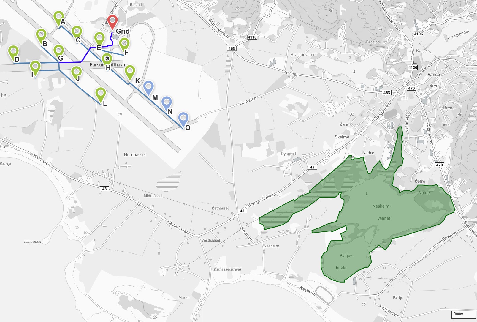 Figure 13.1: Overview map showing planned station placements (A–O) in relation to Nesheimvatnet Nature Reserve (green area). The nearest station (O) is located approx. 1.4 km from the reserve boundary.
Protected area status: - Name: Nesheimvatnet Nature Reserve - Protection type: Nature Reserve - Protection date: Protected as part of the Lista Wetland System - Management authority: County Governor of Agder
Assessment: - The planning area does not directly affect Nesheimvatnet Nature Reserve - Distance from the nearest station (O) to the reserve boundary is approx. 1.4 km - AWE operation in the airspace above the airport will not directly affect wetland functions - Birds migrating between Nesheimvatnet and other wetlands (Slevdalsvatnet, Lista Wetland System) are monitored as part of the bird monitoring programme
Conclusion: The project does not directly affect the Nesheimvatnet area. The distance from the nearest station to the reserve boundary is assessed as sufficient to avoid direct disturbance of wetland functions. Bird activity in the corridor between the wetlands is followed up through the monitoring programme.
14. CULTURAL HERITAGE AND CULTURAL ENVIRONMENT
14.1 WW2 Cultural Heritage
Lista Airport has extensive WW2 history:
| Cultural heritage site | Status | Location |
|---|---|---|
| Runway and infrastructure from 1942 | Listed | Planning area |
| Hangar 45 (Festung Lista museum) | Protected | Planning area |
| Nordberg Fort | Listed by the Directorate for Cultural Heritage | 500 m north |
| Marka Battery | Listed | Planning area |
14.2 Automatically Protected Cultural Heritage
The Penne rock carving site: - Approx. 3,000 years old (Bronze Age) - 22 boats, two footprints, approx. 70 cup marks - Location: North of the planning area, in the West Lista cultural landscape - Status: Automatically protected (older than 1537)
Hervoll Mill: - Two old grain mills - Location: East of Nordberg Fort - Functions as a museum
14.3 Cultural Landscape
West Lista selected cultural landscape: - National status (KULA register) - Stone walls and agricultural landscape - Biodiversity and cultural heritage - Norway's highest density of ancient monuments
Listastrendene Landscape Protection Area (1987): - 8,012.5 decares - Distinctive natural and cultural landscape - Geological, botanical and cultural historical qualities
14.4 Festung Lista — Historical Context
Lista Airport was during WW2 part of "Festung Lista" — an extensive German military complex: - Approx. 300 buildings erected by the occupying power - Lundebanen (narrow-gauge railway to Lundevågen, opened 1943) - Marka Battery (field guns with 22 km range) - Approx. 10,000 workers engaged in the construction
Museums in the area: - Festung Lista Hangar Museum (Hangar 45) - Nordberg Fort (listed by the Directorate for Cultural Heritage, museum since 2009)
14.5 Assessment
The AWE facility: - Does not directly affect ground-based cultural heritage sites - No excavation or construction work near listed objects - Ground stations are placed on existing paved surfaces - Visual impact on the cultural landscape is assessed in section 10 - Operation in the airspace does not affect physical cultural heritage sites
15. PUBLIC HEALTH AND RESIDENTIAL ENVIRONMENT
15.1 Nearest Settlement
| Area | Distance | Number of residences |
|---|---|---|
| Nordberg | ca. 500 m | [antall] |
| Borhaug | ca. 1 km | [antall] |
15.2 Overall Assessment
Based on: - Noise (section 11): Within limit values - Visual impact (section 10): Moderate, reversible - Shadow flicker (section 12): Negligible - Outdoor recreation (section 13): Minimal impact
Overall assessment: Acceptable impact on public health and residential environment.
16. CO-USE AND COORDINATION
16.1 Current Users of Farsund Airport
Lista/Farsund Airport is a multi-use arena. The following actors use the airport area regularly:
- Flying clubs (parking, maintenance, refuelling)
- Agriculture (sowing and harvesting of grass on and around the airport area)
- Kitemill AS (wind power production and R&D)
- Military drones, non-based air traffic, rescue services and events
16.2 Coordination Principle
Established aviation, military activity and rescue services take priority over AWE operations. Kitemill's systems are designed for rapid landing, and operations are adapted to other activities.
16.3 Coordination Measures
The following measures will be implemented in collaboration with Farsund Lufthavn AS:
- Time-slot-based planning: Operational periods are organised in blocks that can be reserved and cancelled with set deadlines, ensuring predictability for all parties.
- Dialogue and input meetings: Regular meetings with the airport's other users and the local community to adapt operational patterns.
- Communication tools: Telephony and aviation radio are used for direct coordination, in line with established practice at airports.
16.4 Private Airstrip
There is a private landing strip in the vicinity of station L. Kitemill is aware of this and will comply with applicable rules for obstacle surfaces and height restrictions also for this airstrip.
16.5 U-space Airspace Organisation
Kitemill plans to implement the European U-space regulatory framework (EU Regulation 2021/664) for organising airspace activity at Farsund Airport. This involves the use of a USSP (U-space Service Provider), for example AirDodge, for coordination between AWE operations and other aviation activity. The experience from this implementation may form the basis for future airspace organisation at other AWE facilities in Norway.
17. NATURAL HAZARDS AND SAFETY
17.1 Ice Throw
Note: For conventional wind power, ice throw from rotor blades constitutes a documented risk. For AWE systems, this issue is significantly different.
Under icing conditions, the AWE system will: - Automatically land (cannot fly with ice on the wing) - Not operate under icing conditions - Risk of ice throw is assessed as negligible
17.2 Tether Length and Operational Limitations
Each AWE system operates with tethers of up to 1,500 metres. Actual tether length used will vary between systems and wind directions — certain station placements and wind directions entail significant limitations in maximum tether length, determined through the operations permit. Maximum tether length and operational volume for each station are determined through a dedicated approval process with the Civil Aviation Authority, based on the SORA methodology (Specific Operation Risk Assessment). This risk assessment takes into account the system's placement, proximity to settlement, airspace classification and other local conditions.
The SORA approval means that systems operating near the outer boundaries of the project area may have limitations in maximum tether length and operating altitude in certain directions. Safety zones around each station are dimensioned so that a kite, in the event of loss of control, will glide down and land within the defined zone. The kite is equipped with an independent emergency system that, upon loss of communication or control, automatically steers it to a controlled descent and landing.
Kitemill continuously cooperates with the Civil Aviation Authority on the approval process for unmanned aircraft. Approval takes place stepwise, and operational limitations may also apply at startup which are gradually adapted as operational experience and documentation accumulate through the operational period. The project timeline (cf. section 5) shows that this permit follows after the granting of the concession.
17.3 Emergency Preparedness
- Operator always present during operation
- Automatic landing system
- Emergency procedures established
17.4 Civil Aviation Authority Assessment
The Civil Aviation Authority has in its consultation statement to Farsund Municipality (ref. 25/18542-2, May 2025) stated:
"The Civil Aviation Authority is generally positive towards technological development in the drone industry, and has no objections to using Lista Airport for testing purposes as long as air and ground risk is managed through the existing and any new approvals."
The Civil Aviation Authority has further recommended that Kitemill apply for new airspace restrictions around the operations area to ensure the safety of other air traffic at the full-scale demonstration facility. Kitemill will follow this recommendation.
The Civil Aviation Authority has already established danger area EN D257 for Kitemill's existing operations at Lista Airport, ensuring that other aviation is notified of the activity. For the full-scale demonstration facility, Kitemill will apply for updated airspace restrictions covering the expanded operations area. This includes:
- Updating the danger area to cover the expanded operations area
- Measures to prevent unintended use of the runway during operations
- Coordination with the airport's existing PPR system (Prior Permission Required)
17.5 Ground Risk
The Civil Aviation Authority distinguishes between operational categories with different ground safety requirements. For all categories, it is Kitemill's responsibility to ensure the safety of persons on the ground — the public is not subject to any restrictions.
Normal operation: Operation over sparsely populated area where ground risk has been assessed and accepted by the Civil Aviation Authority through the operations permit.
R&D operations: When testing new configurations or procedures, operations are adapted so that only approved operation types are conducted over areas where persons may be present. Kitemill monitors the area and adapts operations accordingly.
17.6 Flood and Landslide Risk
The planning area is located on flat ground at Lista Airport. The area has varied surfaces — paved runway, taxiways and perimeter tracks with concrete surface, as well as cultivated land where the ground stations are placed. The risk of landslides is assessed as negligible due to flat topography.
For flood risk, station placements will be assessed against a 20-year flood. Where local ground conditions warrant it, the terrain will be raised with fill material or drainage improved to secure the ground stations. The project's temporary nature and container-based ground stations mean that the facilities can be relocated if needed.
18. CUMULATIVE IMPACT
18.1 Existing Impact in the Area
The Lista area already has: - Airport with air traffic - Agricultural activity - Tourism and outdoor recreation - Existing infrastructure
18.2 Cumulative Effects
| Factor | Existing | AWE contribution | Combined |
|---|---|---|---|
| Noise | Air traffic | Low addition | Acceptable |
| Visual | Hangars, buildings | Moderate | Acceptable |
| Birds | Air traffic, agriculture | Monitored | Managed through monitoring programme |
18.3 Other Plans in the Area
No other planned energy projects or major development measures in the immediate vicinity of the planning area that would entail additional cumulative impact are known. Solkraft Lista AS has plans for solar panel installation on the airport area, and this project is coordinated with NAWEP through joint grid connection.
19. NO-ACTION ALTERNATIVE
19.1 Definition
The no-action alternative is the situation if the NAWEP project is not implemented.
19.2 Consequences of the No-Action Alternative
Energy Production and Climate Targets
If the project is not implemented, no renewable energy from AWE technology will be produced in Norway. At mature operation, the project could deliver up to 4.2 GWh annually to the regional grid (price area NO2), which in recent years has had higher electricity prices than other price areas in Norway (cf. Section 2.4.1). Based on the EU Innovation Fund's calculation methodology (emission factor 0.15 tonnes CO2e/MWh), this corresponds to an annual greenhouse gas saving of approximately 630 tonnes of CO2 equivalents at mature operation.
Norway has committed to 55% emission reductions by 2030 and 70-75% by 2035. The Energy Commission has identified a need for at least 40 TWh of new power production. Although NAWEP in isolation represents a limited volume, the project's primary climate contribution is to develop and document a technology that, when commercially scaled, can provide significantly greater contributions with lower resource consumption than conventional alternatives.
Knowledge Building and Biodiversity
Without NAWEP, no systematic knowledge about the interaction between AWE technology and Norwegian nature will be established. The project is designed to generate data on bird activity, visual impact, noise and operational adaptations that will form the basis for knowledge-based management in the event of future rollout of AWE in Norway. This knowledge cannot be replaced by experience from other countries, as local natural conditions and migratory routes are site-specific.
Existing pressures on the planning area from air traffic and agriculture will continue unchanged regardless of the no-action alternative.
Technology Development and Norwegian Industrial Position
Through Kitemill, Norway holds a significant position in the AWE sector internationally. The company is among the most established and active developers of airborne wind energy globally. If NAWEP is not implemented, this position may be weakened. Technology development will continue in other countries -- Germany has already introduced a feed-in tariff for AWE, and several European actors are preparing demonstration facilities. The EU has invested EUR 3.35 million in NAWEP through the Innovation Fund, and failure to implement will reduce Norwegian influence on the technology's further development and future regulation.
Local Value Creation
The no-action alternative means that no jobs or R&D activity related to AWE will be created at Lista. The airport's suitability as a location for renewable energy production and technology development will not be tested, and the region will miss out on associated business development and knowledge-based employment.
19.3 Assessment
The no-action alternative means that the opportunities for climate transition, knowledge building, local value creation and Norwegian industrial position in an emerging technology will not be realised. The project's mitigation measures are designed to limit the impact on biodiversity to a minimum, and the limited reduction in pressures that the no-action alternative entails must be weighed against the opportunities the project represents.
20. MITIGATION MEASURES
20.1 Overview
| Measure | Description | Period |
|---|---|---|
| Gradual scale-up | From 1 to 15 systems over 3 years (installation) | 2026-2028 |
| Daytime-only flying in the initial phase | Avoids nocturnal migratory activity | 2026 |
| Limited night flying under observation | Only when equipment is ready | 2027 |
| Operational shutdown during peak migration period | Shutdown when bird activity is highest | 2028+ |
| Bird monitoring (field campaigns) | Seasonal campaigns in spring, summer and autumn | 2026-2031 |
| Annual evaluations | Acceptable impact must be documented before continued operation | 2029-2031 |
| Dialogue with authorities | Sharing of data with the County Governor and NVE | Continuous |
21. COMMITMENTS
Kitemill AS commits to:
- Conduct bird monitoring through field campaigns in relevant seasons (spring, summer, autumn)
- Share all collected data with the County Governor and NVE
- Implement operational shutdown during the peak migratory bird period
- Conduct annual evaluations and only continue operation where impacts are acceptable
- Adjust or reverse the plan in the event of unacceptable consequences
- Maintain close dialogue with the County Governor throughout the entire period
- Contribute to increased knowledge about birds and migratory birds at Lista, including spring migration and AWE-specific bird behaviour
22. APPENDICES
Documents
| No. | Appendix | Filename | Description |
|---|---|---|---|
| 1 | NNI Report 520 | Available online | Ornithological survey Lista 2018 |
| 2 | Bouman, N. (2023) -- Acoustic field measurements | Available online | Acoustic measurements KM1 system, Lista Airport. Master's thesis, TU Delft |
| 3 | Glitre Nett maturity assessment | 241121 Glitre - Modenhetsvurdering.pdf |
Grid connection assessment |
| 4 | Dispensation decision Farsund municipality 2025 | Vedlegg 4 - Dispensasjon Farsund Kommune 2025.PDF |
Case extract case 61/25, Committee for Technical Affairs 17.06.2025 |
Maps and KML Files
| No. | Appendix | Filename | Description |
|---|---|---|---|
| 5 | Regional overview map | files/MapRegionalWithArea.jpg |
Regional context, project area location |
| 6 | Local overview map | files/MapNærmiljøet.jpg |
Local surroundings with settlements and topography |
| 7 | Station placements | files/Bilde3.png |
Map with stations A-O and grid |
| 8 | Infrastructure map | files/Map_Bygninger og veier.jpg |
Buildings, roads and settlements |
| 9 | Protected areas map | files/Map_OPSområdet_alle verneområder.jpg |
All protected areas in the region |
| 10 | Protected areas and species hotspots | files/Map_OPSområdet_alle verneområder og hotspots_arter.jpg |
Protected areas with species registrations |
| 11 | Slevdalsvannet and Nesheimvatnet | files/Map_OPSområdet_Slevdalsvannet_Nesheimsvannet.jpg |
Nearest nature reserves |
| 12 | Grid drawings | GRIDtegninger21.02.2025v1.kml |
KML file for map display |
| 13 | Operations area | Operasjonsområdet tegninger6.11.2024.kml |
Operations boundaries |
| 14 | Danger area airspace | 250225_DangerArea.kml |
Danger area definition |
| 15 | Nature conservation areas Nesheimvatnet | Naturvernomrader_Nesheimsvannet.kml |
KML file for map display |
| 16 | Nature conservation areas Slevdalsvannet | Naturvernomrader_Slevdalsvannet.kml |
KML file for map display |
Visualisations
| No. | Appendix | Filename | Description |
|---|---|---|---|
| 17 | 3D view southern stations | files/Bilde7.png |
Station placements F, H, K, M, N, L |
| 18 | 3D view all stations | files/Bilde8.png |
All 15 stations with operational pattern |
| 19 | Aerial photo operation circles | files/Bilde9.png |
Circular movements seen from above |
| 20 | Aerial photo alternative angle | files/Bilde10.png |
Operational pattern and landscape |
| 21 | Ground level - circular movements | files/Bilde32.png |
Visual impact from the ground |
| 22 | Ground level - all kites | files/Bilde33.png |
15 kites in operation from the airport |
| 23 | Actual photo from flight | files/ActualKM1FlightVisuals.jpg |
KM1 system in operation at Lista |
Other Documents
| No. | Appendix | Description |
|---|---|---|
| 24 | Contact persons and stakeholders | Contact information for municipality, grid company and subject matter experts |
Kitemill AS Flyplassveien 40, 4560 Vanse Org.nr.: 994 720 023
Farsund, February 2026